No edit summary |
@DeletedUser40342150 (talk | contribs) No edit summary |
||
| (3 intermediate revisions by 2 users not shown) | |||
| Line 14: | Line 14: | ||
:I do not think that the game engine would allow that.--{{User:Sandwichman2448/Sig}} 02:03, July 23, 2010 (UTC) |
:I do not think that the game engine would allow that.--{{User:Sandwichman2448/Sig}} 02:03, July 23, 2010 (UTC) |
||
| + | |||
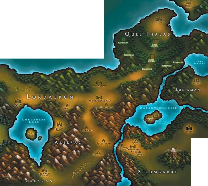
| + | I agree, sandwich. but look how similar to the WC3 map it becomes... --[[User:N'Nanz|N'Nanz]] ([[User talk:N'Nanz|talk]]) 17:14, July 23, 2010 (UTC) [[Image:LordaeronQuelThalasWC3.jpg|thumb]] |
||
| + | |||
| + | :It really does not. This is a pet peeve of mine. The bay between Sunstrider Isle and the unused nub north of Silvermoon in WoW is not the same as the bay that the Sunwell Grove sat near in Warcraft III. If it was, Silvermoon would be where Sunstrider Isle is. Also, Quel'Thalas is not a peninsula on that Warcraft III map. It is an optical illusion caused by where the map border is. Lake Abassi is cut off, but because it is a lake, it must have an eastern shore. Therefore, the land that equates to the nub north of Silvermoon in WoW must also wrap around the lake, making the whole thing a landmass that is not a skinny peninsula. One can not use the river that flows from Lake Abassi to Darrowmere Lake as a coastline, as it is not. A minor adjustment like turning the peninsula a bit that will not make it like the Warcraft III map, so you can not use the Warcraft III map as support. Ideally (per Warcraft III), the Thondroril River should cut diagonally through the Eastern Plaguelands, Quel'Thalas should lay diagonally across the northern boarders of both the Eastern and Western Plaguelands, and a much bigger Zul'Aman should be where Acherus: The Ebon Hold is. Sort of like [[:File:WoWLordaeron.jpg|this]].--{{User:Sandwichman2448/Sig}} 20:19, July 23, 2010 (UTC) |
||
| + | |||
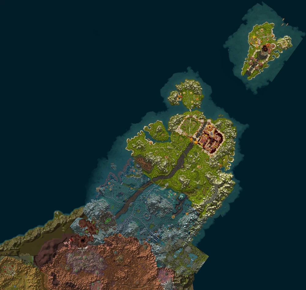
| + | Yes, you are right but don't forget that what we see in the satelite map is only a portion of Zul'Aman. Lake Abassi, Shrine of Ula-tek and Maisara Hills are not present in-game (but they should extend behind the unused tribal gate/portal near Tor'Watha). As I said, the map I uploaded look more similar to the WC3 map that the In-game map, I didn't tell they are the same. After all Stratholme is not that far from the Elfgate (if we consider Thalassian Pass as the outer elfgate), nor Hearthglen is located that Southward... --[[User:N'Nanz|N'Nanz]] ([[User talk:N'Nanz|talk]]) 09:19, July 24, 2010 (UTC) |
||
| + | |||
| + | :The Geography of the Eastern Kingdoms has been changed tons of times since Orcs & Humans, I think at this point, Blizz can basicly recreate a brand new one and call it cannon. [[Image:Pokeball.jpg]] [[User:Max Krist|Max Krist]] ([[User talk:Max Krist|talk]] [[Special:Contributions/Max Krist|contribs]]) 07:55, July 25, 2010 (UTC) |
||
Latest revision as of 07:55, 25 July 2010
Anybody who played TBC knows how -geographically and from a game mechanics POV- Deatholme lays upon the instanced version of Stratholme. How do developers should solve this issue with the addition of flying mounts in Cataclysm? If you look at the Eastern Kingdoms map of Cataclysm it seems they are going to shift the Ghostlands more East?
--N'Nanz (talk) 19:12, July 21, 2010 (UTC)
- They've stated several times you won't be able to fly directly from EPL to Ghostlands that you'll have to use that white portal. So I don't think they're going to do anything.. though it would be nice if they did.

 (Sssss/Slithered) 20:06, July 21, 2010 (UTC)

After a night of brainstorming here is the solution: take Quel'thalas (Ghostlands, Eversong Woods, Quel'Danas + Zul'Aman) and pivot it on Thalassian Pass by 30°. Nothing collides, only untextured areas gone in North-East EPG :D --N'Nanz (talk) 09:09, July 22, 2010 (UTC)
I agree, sandwich. but look how similar to the WC3 map it becomes... --N'Nanz (talk) 17:14, July 23, 2010 (UTC)

- It really does not. This is a pet peeve of mine. The bay between Sunstrider Isle and the unused nub north of Silvermoon in WoW is not the same as the bay that the Sunwell Grove sat near in Warcraft III. If it was, Silvermoon would be where Sunstrider Isle is. Also, Quel'Thalas is not a peninsula on that Warcraft III map. It is an optical illusion caused by where the map border is. Lake Abassi is cut off, but because it is a lake, it must have an eastern shore. Therefore, the land that equates to the nub north of Silvermoon in WoW must also wrap around the lake, making the whole thing a landmass that is not a skinny peninsula. One can not use the river that flows from Lake Abassi to Darrowmere Lake as a coastline, as it is not. A minor adjustment like turning the peninsula a bit that will not make it like the Warcraft III map, so you can not use the Warcraft III map as support. Ideally (per Warcraft III), the Thondroril River should cut diagonally through the Eastern Plaguelands, Quel'Thalas should lay diagonally across the northern boarders of both the Eastern and Western Plaguelands, and a much bigger Zul'Aman should be where Acherus: The Ebon Hold is. Sort of like this.--SWM2448 20:19, July 23, 2010 (UTC)
Yes, you are right but don't forget that what we see in the satelite map is only a portion of Zul'Aman. Lake Abassi, Shrine of Ula-tek and Maisara Hills are not present in-game (but they should extend behind the unused tribal gate/portal near Tor'Watha). As I said, the map I uploaded look more similar to the WC3 map that the In-game map, I didn't tell they are the same. After all Stratholme is not that far from the Elfgate (if we consider Thalassian Pass as the outer elfgate), nor Hearthglen is located that Southward... --N'Nanz (talk) 09:19, July 24, 2010 (UTC)